East Bend Methodist Church Site (East Bend, Ky.)
Item
- Title
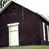
- East Bend Methodist Church Site (East Bend, Ky.)
- Description
- The cemetery south of the church has been in use from the 1960s, while the cemetery to the north was not used until the mid-20th century. A privy behind the church was constructed after the church's period of significance. --National Register Nomination
- Years duration
- 1800- current
- Parent division/institution
- East Bend Methodist Church (East Bend, Ky.)
- Political division
- East Bend (Ky.)
- Latitude
- 38.91910725
- Longitude
- -84.85855161
- Target coordinates
- 685651.931 m
- 4309980.006 m
- Source
-
 Boone County GIS
Linked resources
| Title | Class |
|---|---|
 East Bend Methodist Church Building (East Bend, Ky.) East Bend Methodist Church Building (East Bend, Ky.) |
Location |
| East Bend Methodist Church Cemetery (East Bend, Ky.) | Location |
| Title | Class |
|---|---|
| East Bend Methodist Church (East Bend, Ky.) | Organization |