J.A. Wilson Cemetery (Rabbit Hash, Ky.)
Item
-
Title
-
J.A. Wilson Cemetery (Rabbit Hash, Ky.)
-
Description
-
This is a family cemetery measuring 60 x 50 feet, and containing 20 known internments. Burials range from 1865-1943. The location and boundaries were mapped in 2000.
-
Slave holder or African American Burials: No
-
Has beginning
-
1865
-
Has end
-
1943
-
Identifier
-
Boone Co. GIS Cemetery ID: 192
-
USGS GNIS Feature ID: 506893
-
Find A Grave Cemetery: #76601
-
Latitude
-
38.94487912000
-
Longitude
-
-84.83431495000
-
Target coordinates
-
687685.357 m
-
4312889.982 m
-
Bibliographic citation
-
Boone County, Kentucky Cemeteries, pages 338-339
Linked resources
Items with "Related resource: J.A. Wilson Cemetery (Rabbit Hash, Ky.)"
| Title |
Class |
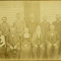 Wilson family Wilson family |
Organization
|
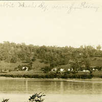 Rabbit Hash (Ky.)


 Stephens, Jane Kendall
 Wilson, James Alexander