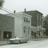
Kento-Boo Baptist Church Building (Florence, Ky.)
Item
- Title
- Kento-Boo Baptist Church Building (Florence, Ky.)
- Description
- Denomination: Baptist
- Years duration
- 1900- Current
- Identifier
- Boone Co. GIS ID: 634
- Full address
- 634 Kentaboo Avenue, Florence, KY 41042
- Political division
-
 Florence (Ky.)
- Latitude
- 39.01322405
- Longitude
- -84.62327058
- Target coordinates
- 705779.229 m
- 4320931.661 m
- Source
-
 Boone County GIS
Linked resources
| Title | Class |
|---|---|
| Kento-Boo Baptist Church (Florence, Ky.) | Organization |