Unidentified Cemetery 3 (Boone County, Ky.)
Item
-
Title
-
Unidentified Cemetery 3 (Boone County, Ky.)
-
Alternate name
-
Unidentified
-
Description
-
The cemetery is purported to be located on the Boone-Kenton County Line. Boone County GIS has no confidence in the accuracy of the location, which was reported by an informant. The cemetery is located near the H. Helm property in the 1883 atlas. There is no cemetery register.
-
Slave holder or African American Burials: No
-
Identifier
-
Boone Co. GIS Cemetery ID: 178
-
Latitude
-
39.05257429000
-
Longitude
-
-84.62174851000
-
Target coordinates
-
705796.788 m
-
4325302.648 m
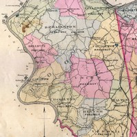 Florence Precinct (Boone County, Ky.)