Sugartit (Ky.)
Item
-
Title
-
Sugartit (Ky.)
-
Alternate name
-
Gunpowder (Ky.)
-
Pleasant Ridge (Boone County, Ky.)
-
Description
-
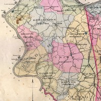
Sugartit is the colorful name for the community that was located at the crossroads of Pleasant Valley Road and the turnpike between Union and Florence. The Gunpowder Creek community was referred to as “Pleasant Ridge” on the 1883 Atlas of Boone, Kenton, and Campbell Counties, Kentucky.
-
Although the community is gone, at one time the crossroads had both a saw and grist mill, as well as a toll gate and a general store.
-
The Germanna families of Tanner and Aylor operated farms along the creek.
-
Before date
-
1883
-
Identifier
-
USGS GNIS Feature ID: 504705
 Florence Precinct (Boone County, Ky.)

 Aylor family