-
Hopeful Heights (Florence, Ky.)
The Hopeful Heights neighborhood developed as a sparsely populated agricultural area, owned mainly by families who were connected to the Hopeful Lutheran Church. With the growth of Boone County and the development of the Florence Mall and the expressway, this little community began to grow a great deal.
-
 Hebron (Ky.)
 The town of Hebron was founded in the mid-19th century, though the exact date is unknown. During its early days it was variously known as Briar Thicket, Briar Patch or Tailholt – all names whose origins are equally unknown. In the end, it was named for Hebron Lutheran Church with whose early history it is closely intertwined.
-
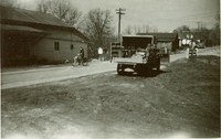
Hathaway (Ky.)
Hathaway was located along Hathaway Road west of the intersection of Camp Ernst Road.
-
Hamilton (Ky.)
Though no longer in existence, Hamilton was once the largest town in the Big Bone area. Established in 1835, the town was originally named 'Landing.' The plat was laid out by Joel Hamilton and George McGlasson.
-
Gasburg (Ky.)
Gasburg was a small community downriver from Petersburg along Belleview Road. The general location is at Lucas Park and Adena Trail. The town derived its name from the numerous natural gas wells that dotted Boone County's western corridor. Residents included Frank Hartmann, and the Terrill, Berkshire and Batchelor families.
-
Garrison Creek (Boone County, Ky. : Town)
Garrison or Garrison's Creek was named after the little creek that the community grew up around along the Ohio River. The farming community sat between Bullittsburg Baptist Church and the Ohio River. At one time, the community had a school and a grist mill.
-
Francisville (Ky.)
Francisville is a little community located along North Bend Road (SR 237) north of I-275. No one is certain of whom Francisville was named for, but the name appears on the 1883 Atlas of Boone, Kenton and Campbell Counties, Kentucky. Sand Run Baptist Church, which dates to the mid-1800's, is located within the community, along with it's associated cemetery. Well-known Francisville families include: the Goodridge family; the Hayes family, and the Stephens family.
-
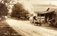
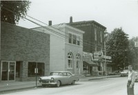 Florence (Ky.)
 Florence, a major crossroads community, was established at the intersection of roads from Covington to Louisville and Lexington. Ten miles from Covington, it eventually became the first stagecoach stop on the trip south.
-
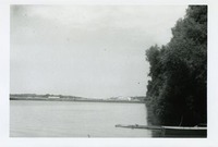
East Bend (Ky.)
East Bend is a riverfront region of Boone County named for the Ohio River's sharp turn eastward. On the western edge of East Bend, there was once a trading post run by a man named DeHart or D'Hart. Around the bend at a distance of about ten miles, were the natural springs at Big Bone. East Bend was known to have rich bottom land and offered a good view for defense against "Indian attack".
-
Devon (Ky.)
Devon was a quiet little community along the Dixie Highway (US 25) between Florence and Richwood.
-
 Constance (Ky.)
 The town of Constance is located along River Road (KY Route 8), which follows Boone County's northern border. Along with neighboring Taylorsport, it lies on a narrow strip of land at the base of a steep bluff in the Taylorsport Precinct.
-
Commissary Corner (Ky.)
Commisary Corner was a short-lived community located along the Burlington Pike at the intersection of Woolper Road.
-
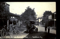
 Burlington (Ky.)
 The county seat, Burlington was originally named Craig's Camp for the early settler John Hawkins Craig. The town was first incorporated as Wilmington in 1800, and then renamed Burlington in 1816. Though it has gone through periods of incorporation throughout it's history, it is presently one of the few unincorporated county seats in Kentucky.
-
 Bullittsville (Ky.)
 The community of Bullittsville is situated along SR 20 between Hebron and Petersburg. According to the 1883 Atlas of Boone, Kenton, and Campbell Counties, Kentucky, Bullittsville was a successful community with both a Masonic and a Grange hall, post office, numerous stores, a school and both a christian and baptist church. Today, the Bullittsville Christian Church remains active in the community.
-
Bullittsburg (Ky.)
The little hamlet of Bullittsburg originated around the Bullittsburg Baptist Church, which by the earliest part of the nineteenth century boasted a congregation of nearly 200 members. The area around Bullittsburg was a bustling neighborhood throughout the nineteenth century. Today, Bullittsburg is considered an extension of the town of Idlewild.
-
 Big Bone (Ky.)
 Big Bone, Kentucky, is an area in southern Boone County. It is bounded on the west by the Ohio River, and Rabbit Hash, on the south by Big Bone Creek, which empties into the river at Big Bone Landing. The northern extent is along Hathaway Road, and the eastern portion extends not further than U.S. 42, and is approached from that direction by Beaver Road (Route 338) coming from either Richwood or Walton.
-
Berkshire (Ky.)
No longer in existence, Berkshire was a town in southern Boone County. It was located south of Verona, though its exact location is no longer known. Berkshire had a post office from 1881 to 1914. Well-known families from the area include: the Anderson Family; the McManama Family; the Waller Family; and the Willeford Family.
-
 Belleview (Boone County, Ky.)
 Belleview is located in the fertile bottoms of the Ohio River. During the mid-nineteenth century, Belleview profited from the Cincinnati to Louisville river traffic along the Ohio. By the 1860s the town had two tobacco warehouses, a hotel and several stores.
-
Beaver Lick (Ky.)
The small community of Beaver Lick in Beaver Precinct, three miles east of Big Bone, was founded in the early 1800's. It may have received its name from the local fur trade, which included plentiful beaver pelts. The town developed around the intersection of the old Louisville Turnpike (now bypassed Dickinson Road) and Beaver Road (KY 1292). It had 25 residents in 1879 and 50 by the end of the century.