-
Hygeia (Boone County, Ky.)
An early visionary retirement community, Hygeia was planned but was never built. It was designed in 1827 by John B. Papworth for William Bullock on the banks of the Ohio River near Ludlow, Kentucky.
-
Waterloo (Ky.)
"A description of our little hamlet, Waterloo is situated on the Burlington and East Bend road; six and one-half miles from Burlington and two and one-half miles from the Ohio River. You will find here farmers who are making a study of their farming and stock-raising, and go about it in a business-like way, making a success of it, gradually increasing their bank account and improving their farms. Fruit growing is given special attention by some. W. B. Kelly has one of the finest orchards in the county, his trees numbering in the thousands. J. W. Kite, who owns the store handles all kinds of first-class merchandise, and a more sociable and clever man can not be found anywhere. J. S. Clore, the telephone man, has charge of the switch-board, and if you want the news, call him and you are sure to get it. Of late there have been several new lines coming into town, more than the present board can accommodate and a new board has been ordered, which will accommodate all the lines and give better service. Waterloo is now one of the most important telephone centers in the county, and lines are being surveyed from a great distance to get connection here." -- Boone County Recorder, 6 Mar 1907
-
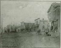 Walton (Ky.)
 Walton is one of the oldest settlements in Boone County, and grew to be the largest town in the county in the late 19th century, due to the Covington-Lexington Turnpike and the advent of the railroads. With the move to interstate travel, Florence has overtaken Walton as the largest town.
-
Verona (Ky.)
Set on a high ridge in the Eden Shale hills of southern Boone County, the town of Verona was established in the mid-19th century and became a post office in 1850. One of its first institutions was the New Bethel Baptist Church, formed in 1840.
-
 Union (Ky.)
 In the central part of Boone County, the Aylor, Fowler, Stansifers and Steers families were among those contributing to the early settlement of the Union area along Fowler's Branch of Gunpowder Creek. In c. 1817 Benjamin Piatt Fowler built a magnificent stone house on part of his father's 5000 acres and, in 1818, Revolutionary War veteran Hugh Steers (buried on the eighteenth green of today's Lassing Pointe Golf Course), donated land for the Bethel Baptist Church on Frogtown Road.
-
Touseytown (Ky.)
Zera (1761 – 1831), Thomas (1775 – 1839) and Moses (1778 – 1834) Tousey settled in Boone County around 1803. They settled on the Ohio River and built Touseytown north of Petersburg where they operated a ferry to Lawrenceburg, Indiana.
-
Taylorsport (Ky.)
The town of Taylorsport is located along River Road (KY Route 8), which follows Boone County's northern border. Along with neighboring Constance, it lies on a narrow strip of land at the base of a steep bluff in the Taylorsport Precinct.
-
Sugartit (Ky.)
Sugartit is the colorful name for the community that was located at the crossroads of Pleasant Valley Road and the turnpike between Union and Florence. The Gunpowder Creek community was referred to as “Pleasant Ridge” on the 1883 Atlas of Boone, Kenton, and Campbell Counties, Kentucky.
-
Stringtown (Boone County, Ky.)
Often mistaken for Florence, KY due to John Uri Lloyd's book "Stringtown on the Pike", Stringtown is located on River Road between Constance and Taylorsport.
-
South Fork (Boone County, Ky.)
Located on Boone County's southern boundary with Gallatin County along the south fork of Big Bone Creek. The little community's focus is the South Fork Christian Church.
-
 Snow's Pond (Ky.)
 Located north of Walton, KY along Dixie Highway or U.S. Hwy 25, Snow's Pond is best known for a Civil War skirmish in 1862. Today, a Historic Roadside Marker marks the event.
-
Richwood (Ky.)
Named for the local church that predated it, the town of Richwood grew up along the Covington-Lexington turnpike (U.S. 25), which linked Northern Kentucky with the Kentucky Bluegrass region. The level to gently rolling farmland around Richwood is the richest in eastern Boone County, and farmers there were well-served by an excellent transportation network.
-
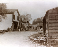
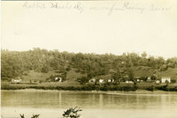 Rabbit Hash (Ky.)
 According to A.M. Yealey, salt and fur agents traveled the Ohio River and crossed at Rising Sun, Indiana via Meeks' Ferry from about 1816 to 1840.
-
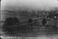 Petersburg (Ky.)
 Originally known as Tanner's Station from 1785-1806, then Caledonia, and finally Petersburg in 1818, it was the largest community in Boone County until the Civil War and the coming of the railroad. The town featured a well laid-out grid street plan, the large Boone County Distilling Company, several other smaller industries, two taverns, many active community businesses and a bustling riverfront.
-
Oakbrook (Ky.)
Oakbrook is the name of the community established in the late 20th century at the edge of Florence and Burlington between Burlington Pike and Pleasant Valley Road.
-
North Bend (Ky.)
Located in the most northern portion of Boone County, the North Bend community shares a name with North Bend, Ohio located just across from each other on the Ohio River.
-
Normansville (Ky.)
Normansville was a small community located at the junction of Beaver and Ryle Roads, near Big Bone Lick and Hamilton.
-
Middle Creek (Boone County, Ky.)
The now extinct town of Middle Creek was located in the Belleview Precinct near the scenic Boone Cliffs (now the Boone Cliffs Nature Preserve). During the 19th century the thriving town included five mills, a distillery, a store, a post office and a Baptist church.
-
McVille (Ky.)
The town of McVille was founded by Green Isaac McMullen in 1881. Overshadowed by Belleview, its larger neighbor, McVille remained a small community whose life was centered on the river. Several steamboats were built there, and it boasted a river landing and a ferry. As of 1883 it included four squares bisected by alleys.
-
Marydale (Ky.)
Marydale was the site of the Order of the Nuns of the Most Holy Cross and Passion of Our Lord Jesus Christ in the Diocese of Covington, founded in 1947. The site was sold in 2015 by the diocese.
-
 Limaburg (Ky.)
 Listed as Florence Crossroads on the 1883 Boone, Campbell, and Kenton Counties, KY Atlas, Limaburg was located east of Burlington on Burlington-Florence Pike (Route 18) where Gunpowder Creek crosses the road. Much of the original town was lost with the reroute and expansion of Burlington-Florence Pike in the late 20th century. The little town once was home to a general store, a black smithy, a mill and a toll house with gate.
-
Kensington (Ky.)
Kensington was a small village along the Lexington Pike in southern Boone County. In 1862, the Skirmish at Snow's Pond took place nearby.
-
Idlewild (Ky.)
Located in Petersburg Precinct in hilly northwestern Boone County, Idlewild (formerly called Gainsville) lies in the valley of Ashby Fork Creek between Bullittsburg and Petersburg. The small village grew up at the junction of the Burlington-Petersburg Turnpike (present KY Route 20), one of the oldest roads in the county, and Idlewild Road (KY 338), which ran parallel to the creek. A tollhouse stood about one-quarter mile to the east.
-
Hume (Ky.)
The community of Hume was located at the intersection of Mudlick Creek and U.S. Highway 42. The Hume family acquired property on Mudlick Creek as early as 1806 and it is thought that ancestors served in the Revolutionary War.
-
Huey's Corners (Ky.)
Huey's Corners is located in Boone County near Union, at the point where Big Bone Road joins Hathaway Road. It was named for Samuel Huey who owned most of the land in the area.